Which photographs in your camera roll are your all-time favourites?
They’re likely the ones with a memorable story behind them.
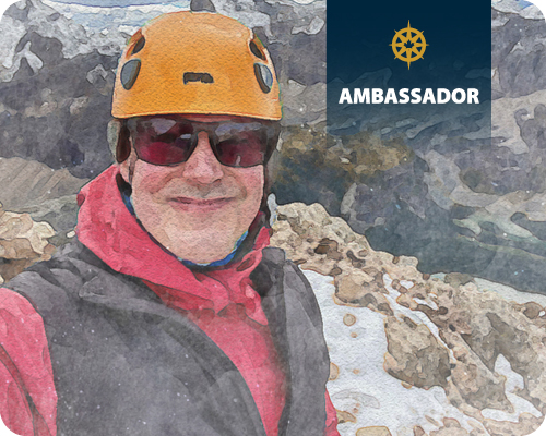
We asked professional photographer and Canadian Geographic Ambassador Scott Forsyth to share the stories behind four of his iconic photographs.
Scott is an alumni host of Canadian Geographic Adventure, a special hiking trip held at CMH during the summer. The trip combines guided hiking with the opportunity to learn from a Canadian Geographic Ambassador who is a pro in their chosen field. Learn more about this trip and who’s hosting this year.
The meaning behind a place
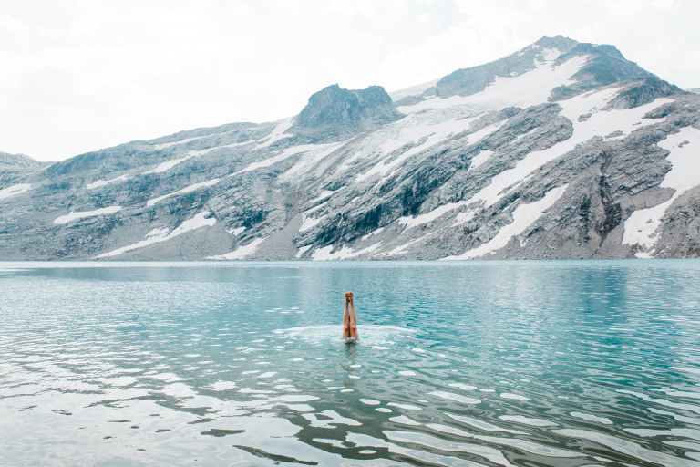
There is nothing more exciting than discovering a new landscape while in the company of others who also value doing so.
So it was with great excitement that I embarked on a pristine alpine immersion in the Cariboo Mountains with Canadian Geographic and CMH Summer Adventures. The stunning beauty of the backcountry of the Canadian Rockies, near my home in Calgary, provided the first inspiration for me to delve into the world of photography 30 years ago.
Since then, I’ve had the privilege to work as a photographic guide along all three of Canada’s ocean coastlines. In 2019, Rocky Mountain Books published my book The Wild Coasts of Canada (winner of the Banff Mountain Film and Book Festival) which features not only the images of seven years of travel along Canada’s remote landscapes but also the stories of the natural and cultural history related to the scenes. The meaning behind a place is as important to me as its appearance.
In 2019, Canadian Geographic designated me with a lifetime Photographer-In-Residence position and named me one of their travel ambassadors. We have a mutual goal to explore Canada and to share those experiences with other Canadians.
“The meaning behind a place is as important to me as its appearance.
Scott Forsyth
What I think about when creating an image
Having spent 30 years working with cameras, I now realize that despite the technical advances, no image we can create compares to the experience of actually witnessing a scene. The most important thing is to be present, and then let the images we see start to naturally appear. Sometimes the drive to ‘get the shot’ can obscure the obvious; the magic of being in the presence of a wonder-invoking place.
Here’s to the joy of anticipation that arises from experiencing something yet unknown.
The stories behind the snaps
I’d like to share with you the background and approach behind four of my photographs that will stick with me forever…
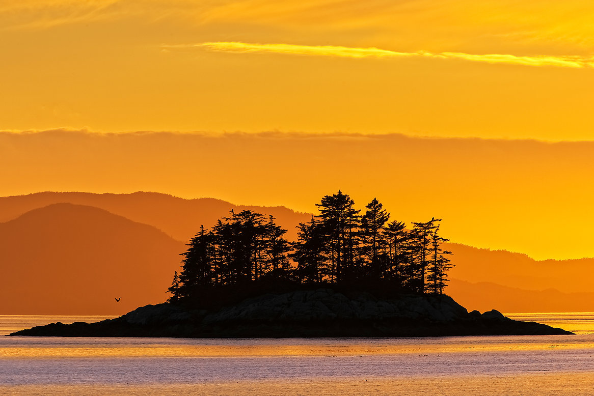
1. Evening Perch
As daylight was nearing its end, a group of us gathered around a warm fire on the white sand beach of Campania Island. Our hands warmed by cups of steaming hot stew, we reflected over the past several days of exploring the Great Bear Rainforest. At six million hectares in size (the size of Ireland) this magnificent region of Canada is the largest intact temperate rainforest in the world. The seed of its creation was planted by Cecil Paul (Wa’xaid) a Xenaksiala elder.
It was in the pristine northern region of the Kitlope, where Cecil’s grandmother tried to hide him from the residential school system. Eventually, he was taken far away (Port Alberni) and the trauma of that experience set him on a difficult struggle for decades until he returned at last to his ancestral home where he experienced healing in these forests. His story is told through Rocky Mountain Books’ publication of The Magic Canoe.
Upon his return to the Kitlope, he discovered survey markers for a logging road. This was the moment he resolved to protect his homeland and its precious ecology, launching an environmental movement over the next two decades. In 2016 the Great Bear Rainforest Land Use Order and Forest Management Act came into being. This is an Ecosystem-Based Management Plan rooted in science as well as traditional local knowledge. It conserves 85 per cent of the forests and 70 per cent of old growth over time, while still ensuring opportunities for economic development and jobs for local First Nations.
Though the warmth of the fire was compelling, I couldn’t resist noticing the wonderfully warm light of sunset illuminating layers of distant clouds on the horizon of Hecate Strait. I down my cup of stew, picked up my camera in exchange, and headed off across the beach toward a small river. When we embrace the world around us, without forcing an agenda, it is very freeing. I started to play with compositions of little subjects along the walk, rocks in a stream, and a lone tree perched atop a pile of boulders. As the light dimmed, I noticed the pronounced silhouette of a nearby uninhabited island contrasted against the colours of the distant sky.
The triangular shape of this island seemed to symbolize a classic Pacific West Coast scene. As I focused my glance through the viewfinder of a telephoto lens, this composition immediately stood out. This is a natural occurrence of a scene resembling a print created by one of my favourite west coast artists, Roy Henry Vickers. As I released the shutter, I noticed a small silhouette of an eagle swooping up to perch on a tree. It wasn’t until I was home that I noticed there were eagles perched atop each of the trees on this island, seemingly appreciating each other’s company in the midst of a beautiful west coast sunset.
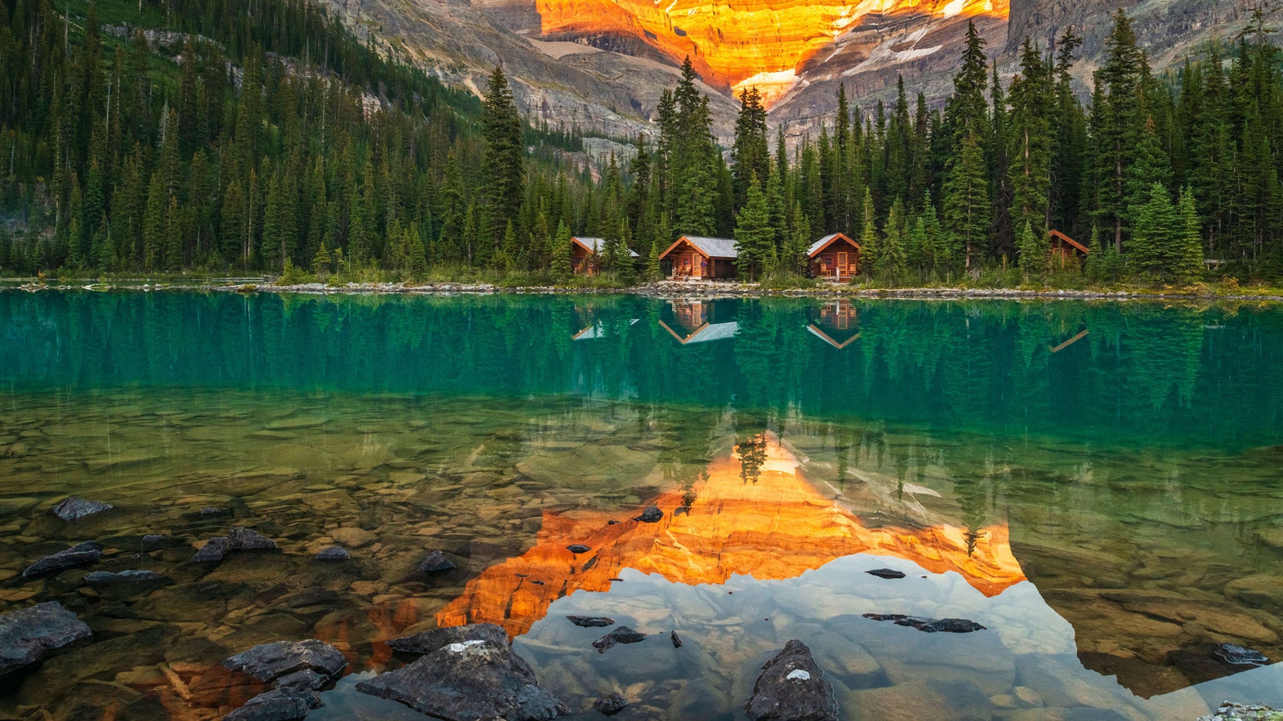
2. Lake O’Hara Sunset
The sensitive alpine environment of the Lake O’Hara region of Yoho National Park, BC, is one of the most beautiful Canadian Rockies hiking destinations in Canada. Surrounded by a network of hanging valleys that each contain glacial lakes of their own, there are numerous well-maintained hiking trails connecting these jewel-blue alpine lakes accompanied by breathtaking vistas.
Some of the vistas in this region, such as the geometric reflections in Lake Oesa (2,270m) may seem familiar thanks to the paintings created by J.E.H. MacDonald, a member of the Group of Seven. He first experienced the scenery here in 1924 and this became a favourite destination for him despite the arduous journey of trekking in with his painting supplies via a mule and rowboat. He returned here for several consecutive years until his health failed him. In her book The Lake O’Hara Art of J.E.H. MacDonald and Hiker’s Guide, author Lisa Christensen traces the footsteps of MacDonald to the very spots from which he painted, even discovering remnants of paint on trees used perhaps to clean a brush.
This jewel of the Rockies has become an annual family trip for me, as it is only a little over two hours away from our home in Calgary. Parks Canada restricts access to this region to provide high-quality and meaningful experiences for visitors and to maintain Lake O’Hara’s unique and fragile alpine environment.
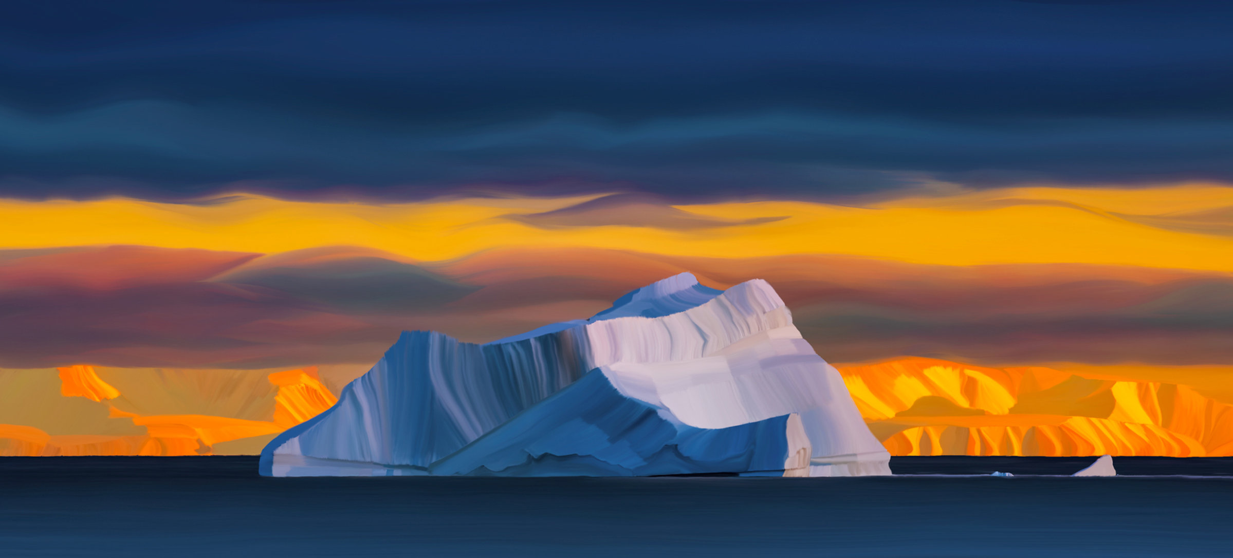
3. Tallurutiup Imanga Sunset
One of the most striking features of Arctic Light is the oblique angle of the sun to the horizon, creating magnificently drawn-out sunsets. This contrasting warm and cold scene lingered for well over an hour, as the sun set across Lancaster Sound, reflecting on a large solitary iceberg on its journey in the ocean current.
This body of water in the Qikiqtaaluk Region of Nunavut forms the eastern entrance to the Northwest Passage. It also falls within the newly created Tallurutiup Imanga National Marine Conservation Area, a boundary protecting 109,000 square kilometres, making it the largest marine conservation area in Canada. The goal of this conservation area is to work with local Inuit to conserve the rich biodiversity of Lancaster Sound and the adjacent waterways. The presence of Polynyas in its waters—small pockets of open water that provide year-round refuge for Arctic marine and bird species during the cold winter months—make this region ecologically critical.
This print is a digital painting based on my original photograph, using a digital tablet and pen. Nature supplied the palette of various hues which the camera sensor captured, while I provided their hand rendering into shapes.
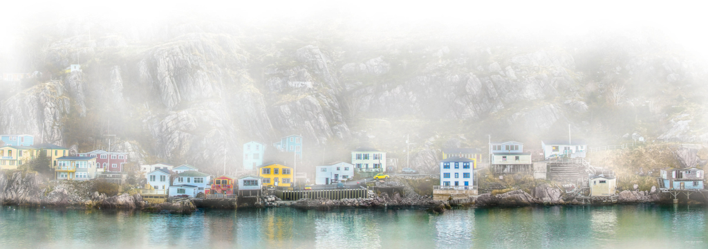
4. Living On the Edge
Upon approaching the Narrows from the sea, the only entrance to St John’s Harbour, it is nearly impossible to see the opening between the towering seaside cliffs that conceal a city lined with colourful homes cascading down steep streets leading to the bay. Aptly named, ‘The Narrows’ is only 61 metres wide at its narrowest and 11 metres deep at its shallowest. Along the entrance, from as early as the 1770s, is Chain Rock, from which a chain was dragged 174 metres across the channel each night to Pancake Rock on the Fort Amherst side, to block the entrance of enemy ships.
Perched along this channel underneath the towering rocks of Signal Hill, from where the first trans-Atlantic wireless signal was received in 1901, are the homes of The Battery. This is North America’s oldest year-round European settlement, and most Easterly community, formed in the 1600s as fishing thrived off the nearby Grand Banks.
It is rewarding to extrapolate from literal photographic images such as in this picture where I have stitched together several images taken while sailing past The Battery one early morning. I then converted the panoramic image to black and white and completely whited out using a digital paintbrush with Corel Paintshop software. I then gradually drew back the underlying original image through the haze and reintroduced the colours of the dwellings, where I want our eyes to be drawn.